What size is the target (subject)?
At what time of day is the lighting best?
From what direction should the pictures be
taken?
From approximately what altitude should the
pictures be taken?
What hazards to safe flight are present in the
target area?
When the photographer and the pilot have the
answers to these questions and understand the
objectives of the mission, both are in a position to
produce quality photographs that meet the needs of the
requester.
To enable the photographer to take pictures, the
pilot must know specific details about the mission.
When taking photographs on the ground, you can
choose to move either the object or yourself to get
proper composition for your pictures. However, in the
air, you must rely on the pilot for the desired camera
angle and the correct camera-to-subject distance. The
pilot cannot read your mind, so it is important to discuss
your plans in detail before the flight. Remember, there
is not time to accomplish this while you are both in
flight.
Other reasons for discussing plans before the flight
are as follows: the mission may require maneuvers the
aircraft is incapable of performing or the pilot may
perform a different maneuver to get the same results.
On the ground, the photographer has sole control over
the camera. In the air, the camera is, so to speak, in the
hands of both the photographer and the pilot. Both must
coordinate their efforts and work together as a team.
MAPS AND CHARTS
For some aerial assignments, a map or chart is
important for the successful accomplishment of an
aerial photographic mission. You should become
familiar with the different types of maps and charts
available. A map is used primarily for land navigation,
while a chart is used primarily for water navigation.
Represented on a map or chart are the essential
topographic features, such as water depths, roads,
railroads, rivers, lakes, towns, cities, airfields, and other
man-made objects.
The scale of a map or chart depends upon personal
choice and availability. A large-scale map provides
greater detail, while a small-scale map covers a larger
area. The scale of the map you use should be large
enough to define the target clearly yet small enough to
include a large area surrounding the target.
Reading a map is easier when the top of the map is
forward, so the map lies in front of you, just as the
ground does. You may find the map easier to use during
the flight when you write on it, so the top is in the main
direction of flight. Once you have located the target on
the map, you should mark it. Indicate the type of
photograph and any other information that may be of
assistance in your photographic mission, such as
altitude, scale, and angle. Geometric North should also
be marked on the map.
WEATHER
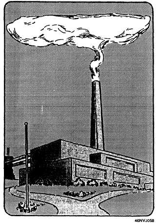
Temperature inversion in the atmosphere tends to
concentrate and trap particles in the air, causing haze.
A common type of temperature inversion may be
characterized by smoke that rises to a certain height,
Figure 4-11.—Characteristic of temperature inversion.
4-11